We plan to map all of the Skylark territories, so far as is reasonably possible and using professional bird surveyors, across the whole area around the location of the transects described above.
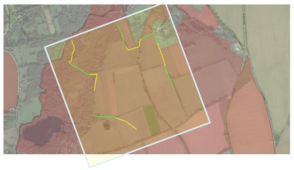
The BTO Breeding Bird Survey methodology requires (so far as is reasonably practicable) two parallel 1km transects within a 1km square. Ideally these should be 500m apart and 250m from the edge of the square. As the BTO Breeding Bird Survey selects and allocates survey squares at random, we will not be participating formally in the survey, however we are using its methodology as a tried and tested survey methodology. We have selected an area of 1km square where there is a healthy population of Skylarks. The optimal area is unfortunately dissected by the cable route for the Norfolk Offshore Windfarm and construction work to lay the cables is expected to take place during 2024. To avoid risk of noise disturbance and potential restrictions on access, we re-located our survey northwards. The revised location still takes in one of the best areas for Skylark and also has the advantage of including a greater range of habitats (including wet carr). The position of fences and hedgerows within this square means that the two transects cannot be perfectly parallel, but they are as close to parallel as practically possible (Figure 1). 200m sections are shown in yellow and green. The red shading shows land that is within WBEP.
Figure 1: Skylark Transects
Questions or problems?
Get in touch and we'll help you get set up.